

El Dorado County, CA
About El Dorado County
El Dorado County Profile:
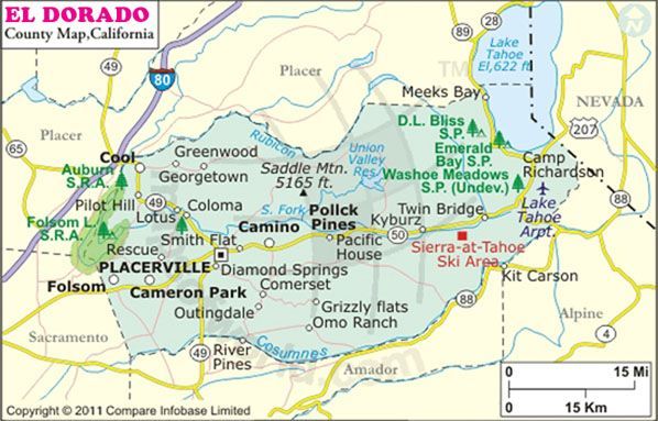
El Dorado is located in the northeastern region of California surrounded by 4 other counties including Sacramento and Placer counties, and the Nevada border.
Governance and Politics:
The county seat for El Dorado County is located in Placerville. The county has operated under a charter since 1994, comprised of a 5 member Board of Supervisors. It is a predominantly republican county as Jimmy Carter was the last presidential democrat to win the county.
Location and Geography:
El Dorado County has a total area of 1,707.88 square miles of rolling hills and mountainous terrain. The county’s western border runs along the western side of Folsom Lake and the county’s western border is part of the California-Nevada border. The northeast corner of the County is part of the Lake Tahoe basin while the remainder of the county is in the “western slope” of Echo Summit. The landscape invites visitors and residents to enjoy a multitude of outdoor recreational activities all year long.
Cities in Sacramento County:
El Dorado County is home to two cities:
- South Lake Tahoe
- Placerville
Unincorporated Communities:
Auburn Lake Trails, Cameron Park, Camino, Camp Sacramento, Cold Springs, Coloma, Cool, Diamond Springs, Echo Lake, El Dorado, El Dorado Hills, Fair Play, Garden Valley, Georgetown, Greenwood, Grizzly Flats, Happy Valley, Meyers, Kyburz, Outingdale, Phillips, Pilot Hill, Pollock Pines, Rescue, Shingle Springs, Somerset, Strawberry, Tahoma, and Twin Bridges.
The history of El Dorado County:
El Dorado County was one of California’s original counties, founded at the time of statehood in 1850. El Dorado is Spanish for “Golden One” which is fitting for a county founded during the Gold Rush.
James Marshall discovered gold in Coloma in 1848 and the population of El Dorado County and California in general exploded with miners hoping to strike it rich. The California Mother Lode vein of gold stretched from El Dorado County down South to Mariposa County.
Demographics:
El Dorado County’s population was approximately 183,087 in 2014 about 0.47% of California’s total population. There are about 106 persons per square mile in El Dorado County.
Income & Affluence:
The median household income in El Dorado County is $69,297 which slightly more than the California median income of $61,094 and about $16,000 above the median income for the country.
Housing and Real Estate:
According to the census bureau, there were over 88,000 housing units in El Dorado County in 2013 with a median home value of owner occupied units from 2009-2013 of $359,500. The homeownership rate is 74.8%.